
PAS128:2022
Underground Utility Mapping
Mapping the unseen - What is PAS128 & Why use it?
PAS128 What is it & why use it?
PAS128:2022 Underground utility detection, verification and location - Specification
It's a Public Available Specification (PAS) that is supported by the British Standards Institute (BSI) which allows clients' and utility survey providers to specify and deliver utility surveys to a robust methodology and deliver them to a recognised level of accuracy and standard
We appreciate that different clients may have varying knowledge of PAS128 and have outlined the various survey types, methodologies, quality levels and limitations on this page to help guide our clients to specifying a PAS128 survey
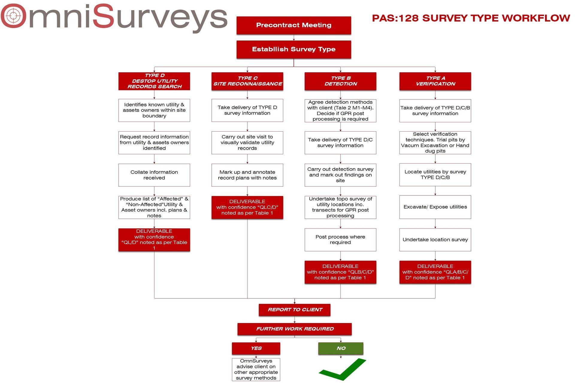
Survey Types
To get the most from a utility detection survey the correct survey requires to be established
PAS128 contains four Survey Category Types assigned D to A. Type A surveys offer the highest level of accuracy and involve intrusive techniques
A walk through of the different survey types
Type D - Desktop Utility Records Search - QL-D
- Starting point for all types of utility surveys
- Extensive search of each asset owner in the survey area
- Collate all notes and plans information from utility owners
- Deliverables
- Desktop report with individual pdf plans
- Augment digital asset plan overlaid onto a suitable background
Type C - Site Reconnaissance - QL-C
- Take delivery of Type D survey data
- Prior to utility detection survey our survey team walks the site checking and visually verifying Type D survey
- Overmark Type D plans with notes and annotations
- Deliverables
- As per Type D with notes from visual site walk over
Type B - Utility Detection - QL-B
- Take delivery of Type D & C survey data
- Identify survey detection methodologies to be used in conjunction with client based on M1-M4 mythologies from the detection methodology table below
- Conduct on site detection utilising Electromagnetic Location & GPR Techniques
- Process data
- Deliverables
- 2D plan drawings both in digital and hard copy
- 3D Models in AutoCADCivil3D
- Manhole & Utility Chamber inspection records
- CCTV drainage network reports
- Georeferenced aerial imaging
- Quality & Confidence levels noted QL/D/C/B1/B2/B3/B4
Type A - Utility Detection - QL-A
- Take delivery of Type D/C & B survey data
- Agree with client areas requiring verification
- Choose verification techniques
- Vacuum Excavation trial pits
- Drainage CCTV inspections
- Locate utilities by Type B survey
- Expose utilities - Vac Ex
- Survey in accurately positions of services exposed
- Deliverables
- 2D plan drawings both in digital and hard copy
- 3D Models in AutoCADCivil3D
- Report of variances between Type A & B Survey
- Cross Sections
- Manhole & Utility Chamber inspection records
- CCTV drainage network reports
- Georeferenced aerial imaging
- Quality & Confidence levels noted QL/D/C/B1/B2/B3/B4/A
Post Surveys De-brief
It is beneficial for a post survey meeting or informal discussion to take place with our clients to review accuracies and quality levels achieved along with any areas of concern that may benefit with further survey types or surveying methods
Accuracies of surveys
A PAS128 survey will commonly have multiple underground utilities in it often located by a variety of the survey types outlined above. It is essential that an accurate level of accuracy of which the survey data is captured to and the confidence that the data captured can be relied upon it
PAS128 does this by attributing Quality Levels "QL" to all utilities featured in a survey. A single utility can have multiple quality levels assigned to its route depending on the methods used to locate it from physical verification , detection by single or multiple geophysical methods or identified from record drawings or visually on site.
The table on the left identifies the quality levels for each type of survey
Type B Surveys - More details
Type B surveys are by far the most common types of surveys specified and one which our array of survey technologies are tailored to specialise in.
The table opposite is extracted from PAS128:2022 and details the "Detection Methods" and expected outputs from them. The term "Detection Methods" should not be confused with the equipment we use to Locate utilities instead think of as the distance between which we search and detect utilities at.
These range from M1-4, it is particularly helpful that when commissioning an underground utility survey that the client uses these methods in specifying how often they wish utilities to be located.
The intervals in which utilities are located between "Detection Methods" can have a considerable variation in costs. for this reason it is essential that our clients work collaboratively with us to tailor each survey to provide best value both financially and quality of survey for the project
PAS128 Underground Utility Surveys - Limitations
Due to the lack of visual physical verification of underground utilities Type D, C and B surveys in most circumstances cannot guarantee 100% location. However they are very reliable for detailed design and should be primary reference for Health & Safety purposes prior to undertaking intrusive works. The primary purpose of PAS128 was for the Health & Safety purpose to assist in the avoidance on accidents around utility works.
As with everything there are limitations that could affect the outcomes of an underground utility survey
- Ground conditions
- Depth of utilities
- Multiple utilities close together or "stacked" in trenches
- Non-metallic utilities - plastic ducts or pipes
- Ductile materials with joints sealed with rubber or plastic
- Electromagnetic field distortion/bleeding from multiple utilities
- "Balanced" AC cables
- Ground Penetrating Radar detected objects need to be larger in diameter the deeper they are located than shallower objects
Like to know more - CPD Events
We appreciate that all the different technologies and terminology is second nature us but to you our clients it may very well be confusing and daunting.
OmniSurveys offer educational "Lunch & Learn" one hour Continuing Professional Development (CPD) educational events to our clients
Our aim with these events to educate and keep our clients staff updated not only on specification changes but with the rapid developments within the geospatial world both in surveying technologies, data capture methods, workflows but how these can enhance quality of deliverables, time and costs.
At these events we explore the Geospatial surveying solutions we offer to give our clients and their staff a better understanding of the different types surveys we offer along with the technologies we use.
This can include:
- Topographical Surveys
- PAS128 - Underground Utility Mapping
- Measured Building Surveys
- Engineering Surveys
- Laser Scanning
- 3D Modelling & BIM Surveys
- UAV Drone Surveys
Having carried out many of these events over the years we have found our clients and their teams have taken a lot away from them and thus resulted in better collaboration providing clients with more tailored surveys with better value through better knowledge.
Tailored events can be arranged on specific topics of interest such as PAS128 Utility Mapping, UAV Surveys, Laser Scanning & Modelling
To book an event please contact us to discuss your requirements
Interested in our services? We’re here to help!
We want to know your needs exactly so that we can provide the perfect solution. Let us know what you want and we’ll do our best to help.